The Ride
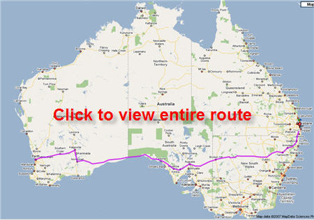
On Thursday September 11, 2008 at 6 am 15 year old Jack Sinclair will set off with his dad, Brendon, on one of the great challenges of ultra endurance bike riding – riding across Australia in 30 days.
- 4,500 kms in 30 days
- Temperatures of 45 degrees C
- Howling head winds
- Driving rain
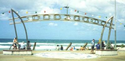
Starting from Perth, Western Australia, the plan is to finish under the “Surfers Paradise” sign (below) located at the eastern end of Cavill Ave, Surfers Paradise on Friday 10 October 2008 at midday – 30 days later.

Here’s How We Did It
Adventure Begins
Good Luck Message
Day 1 – Tailwinds
Day 2 – More than planned
Day 3 – Rolling Plains of WA
Day 4 – Kalgoorlie
Day 5 – Tough Day
Day 6 – Norseman to Balladonia
Day 7 – Massive Day Gets Us Ahead
Day 8 – Past Madura
Day 9 – Crossing the border
Day 10 – Into SA
Day 11 – To Penong
Day 12 – Hardest Ride Ever
Day 13 – To Minnipa
Day 14 – Reducing tomorrow’s ride
Day 15 – 120 km to Port Augusta
Day 16 – An Incredible Day
Day 17 – Australia Bites Back
Day 18 – Broken Hill Birthday Boy
Day 19 – Broken Hill Flying
Day 20 – Pushing Hard
Day 21 – Lunch Update
Day 22 – Heat, Flies & Exhaustion
Day 23 – Stormy Morning, Hot Afternoon
Day 24 – Cycling Hell to Heaven to Hell
Day 25 – Dodging Snakes, Kangaroos & More
Day 26 – Wet & Wild 101 km
Day 27 – 120 kms of Downhill
Day 28 – 130 km Lumpy Ride
Day 29 – The Kyogle Ranges
Day 30 – It’s Here….Coming To The End
End – Done!
Below Is How We’d Planned To Do The Ride
Day 1 – Sept 11, 2008
Perth to Meckering – 144.2 km
The start! At the 34 km mark we come to our first decent hill, a 333 metre climb followed by …click for more (including maps)
Day 2 – Sept 12, 2008
Meckering to Walgoolan – 162.1 km
Passing through Meckering, Cunderdin, Tammin, Bungulla, Kellerberrin, Doodlakine, Baandee, Hines Hill …click for more (including maps)
Day 3 – Sept 13, 2008
Walgoolan to Yellowdine – 106.4
Day 3 is a relatively easy day in terms of length, but a couple of sharp climbs will keep …click for more (including maps)
Day 4 – Sept 14, 2008
Yellowdine to Kalgoorlie – 194.1 km
We’re off to Kalgoorlie with a tough 194 km day. We travel through …click for more (including maps)
Day 5 – Sept 15, 2008
Kalgoorlie to Norseman – 186.6 km
Hines Hill …click for more (including maps)
Day 6 – Sept 16, 2008
Norseman to Balladonia – 214.7 km
Our longest day at a massive 214.7 km, this day will be a real test. The elevation profile shows a …click for more (including maps)
Day 7 – Sept 17, 2008
Balladonia to Caiguna – 161.0 km
This day contains the longest straight road in Australia at an incredible 146.6 km. A fairly …click for more (including maps)
Day 8 – Sept 18, 2008
Caiguna to Madura – 175.8 km
Desolate country out here with just one town to our destination of Madura …click for more (including maps)
Day 9 – Sept 19, 2008
Madura to Eucla – 175.8 km
Another long hard day with not a hill in sight. Day 9 will be tough, with the realisation …click for more (including maps)
Day 10 – Sept 20, 2008
Eucla to Nullarbor National Park – 203.9 km
Another very flat day and we’re loaded up with a 204 km ride, most of it …click for more (including maps)
Day 11 – Sept 21, 2008
Nullarbor National Park to Nundroo – 140.0 km
An easier day of 140 kms, with what looks like a hill (it will be great to …click for more (including maps)
Day 12 – Sept 22, 2008
Nundroo to Ceduna – 154.4 km
A solid flat run heading through Bookabie and Penong, if the breeze stays down it should be a …click for more (including maps)
Day 13 – Sept 23, 2008
Ceduna to Minnipa – 173.0 km
This will be interesting – looks like 173 km of a slow long climb. Passing through Merghiny, Puntabie, Wirrulla …click for more (including maps)
Day 14 – Sept 24, 2008
Minnipa to Kimba – 139.3 km
A bit of an up and down day which finishes up, up and up (don’t you just love that!), as we pass through …click for more (including maps)
Day 15 – Sept 25, 2008
Kimba to Port Augusta – 155.2 km
The elevation chart makes it look like 155 km mostly downhill, so it will be a fairly flat run. At 155.2 kms passing through …click for more (including maps)
Day 16 – Sept 26, 2008
Port Augusta to Oodla – 155.5 km
A nice hard climb to start the day (!) and then a bit more climbing during the day through …click for more (including maps)
Day 17 – Sept 27, 2008
Oodla to Olary – 141.9 km
What goes up must come down. After some decent climbs yesterday, day 17 looks to be a …click for more (including maps)
Day 18 – Sept 28, 2008
Olary to Broken Hill – 117.5 km
Jack turns sweet 16 (!) today and we have a relatively comfortable 117.5 km ride through Mingary …click for more (including maps)
Day 19 – Sept 29, 2008
Broken Hill to Little Topar – 111.6 km
A nice easy day out of Broken Hill through Mt Gipps to Little Topar. A chance to get some rest …click for more (including maps)
Day 20 – Sept 30, 2008
Little Topar to Wilcannia – 104.5 km
The 2nd shortest day of the entire trip – a flat ride through to just outside Wilcannia …click for more (including maps)
Day 21 – Oct 1, 2008
Wilcannia to Noona – 112.5 km
At day 21 we’ll have tired legs, so we’ve factored in another fairly short easy day prior to some long, steep days …click for more (including maps)
Day 22 – Oct 2, 2008
Noona to Cobar – 129.5 km
A slow climb gets us to Cobar – we’re know coming to the business end and …click for more (including maps)
Day 23 – Oct 3, 2008
Cobar to Nyngan – 132.1 km
A climb in the morning sets us up for an easier afternoon with some nice …click for more (including maps)
Day 24 – Oct 4, 2008
Nyngan to Gilgandra – 163.8 km
A long hard day here through the hopefully named Nevertire, Snakes Plain, Taronga, Warren …click for more (including maps)
Day 25 – Oct 5, 2008
Gilgandra to Gunnedah – 201.0 km
A huge day as we’re heading closer to the coast. A long hard climbing day followed by lots of up and downs. This day will leave us …click for more (including maps)
Day 26 – Oct 6, 2008
Gunnedah to Uralla – 165.2 km
Another real tough day of riding through Noggabri, Carroll, Somerton, Bective, Tamworth …click for more (including maps)
Day 27 – Oct 7, 2008
Uralla to Ebor – 100.9 km
This is the shortest day at just over 100 km, but the long hil from the 62 km mark means …click for more (including maps)
Day 28 – Oct 8, 2008
Ebor to Grafton – 117.1 km
Doesn’t that elevation chart look good with it’s downward line the entire way! Looks like a …click for more (including maps)
Day 29 – Oct 9, 2008
Grafton to Kyogle – 132.3 km
Brendon has done the ride before and remembers it as a day of “Hell on wheels”. Exposed rolling roads provide no respite …click for more (including maps)
Day 30 – Oct 10, 2008
Kyogle to Surfers Paradise – 122.6 km
A couple of hard hills get the heart started out of Kyogle and into the ranges. From the Sphinx Cafe it’s a brilliant downhill run to …click for more (including maps)
The Full Trip
Click to see the full detailed route.
Thanks to our mates at Somerset Plumbing Services (the do all sorts of tradesmen stuff) for their support with the ride via a kind donation and help. Really appreciate it guys.


